
Low pressure over Bay set to trigger heavy rains in Odisha
Bureau,Odishabarta
Bhubaneswar: After Cyclone Yaas wreaked havoc in coastal districts of Odisha barely a fortnight ago, a low pressure formed over northwest Bay of Bengal appeared set to bring heavy rains in the western region of the State on Saturday, the Met office said.
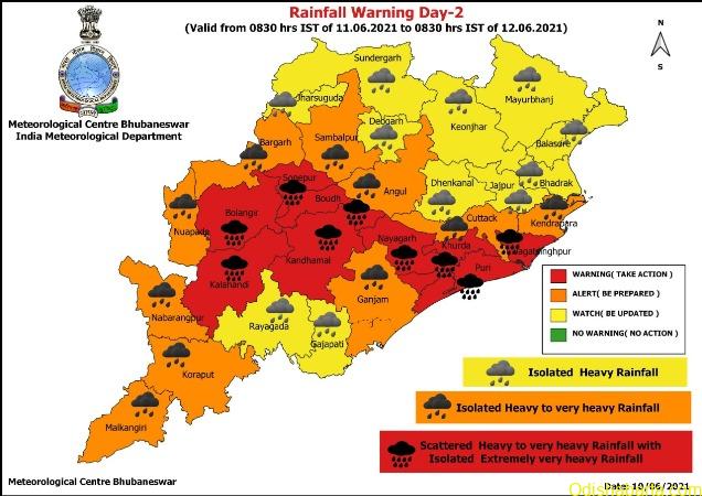
“Heavy to very heavy rainfall is very likely to occur at a few places with extremely heavy falls at isolated places over the districts of Sambalpur, Sonepur, Balangir, Boudh, Bargarh and Angul,” the India India Meteorological Department (IMD) said. The IMD issued red warning, meaning ‘take action’, for these districts.
The weather office also issued an orange warning (alert and be prepared) for the districts of Malkangiri, Koraput, Nabarangpur, Kalahandi, Nuapada, Dhenkanal, Cuttack and Deogarh. For districts such as Jharsuguda, Sundargarh, Keonjhar, Mayurbhanj, Balasore, Bhadrak, Jajpur, Kendrapara, Jagatsinghpur, Khurda, Puri, Nayagarh, Gajapati, Ganjam, Rayagada and Kandhamal, a yellow warning (watch and be updated) is issued. The weather office made a rain forecast for Sunday, Monday and Tuesday also.
Meanwhile, Special Relief Commissioner (SRC) Pradeep Kumar Jena, in a letter to all the district collectors, asked them to closely monitor the situation in the districts for which red, orange and yellow warnings were issued. He said the authorities should be prepared to meet water logging/localised flood-like situation. The SRC also alerted them on the possibility of landslide in hilly areas. He asked the collectors and municipal corporations to evacuate people, if required, from low-lying areas and kutcha houses. The instructions have been given to the Water Resources department to ensure protection of weak and vulnerable embankments in rivers and major nullahs.
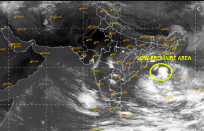
The IMD said the low-pressure area now lies over northwest Bay of Bengal and adjoining Odisha and Gangetic West Bengal coasts. A cyclonic circulation over the sea had led to the formation of the low-pressure on Friday morning. It is likely to become more marked during the next 24 hours and move west-northwest wards across Odisha.
“Under its influence, fairly widespread to widespread rainfall activity with isolated to scattered heavy to very heavy falls are very likely over most parts of east India and adjoining central India from today. Isolated extremely heavy falls (20 cm) are also very likely over Odisha on Friday,” the IMD said.
Squally weather with surface wind speed reaching 35-45 kmph gusting to 55 kmph is very likely to prevail along and off Odisha coast and North Bay of Bengal adjoining west-central Bay Bengal till June 14.
#dinalipi & Photo from IMD